Yarn 4
Texas 200
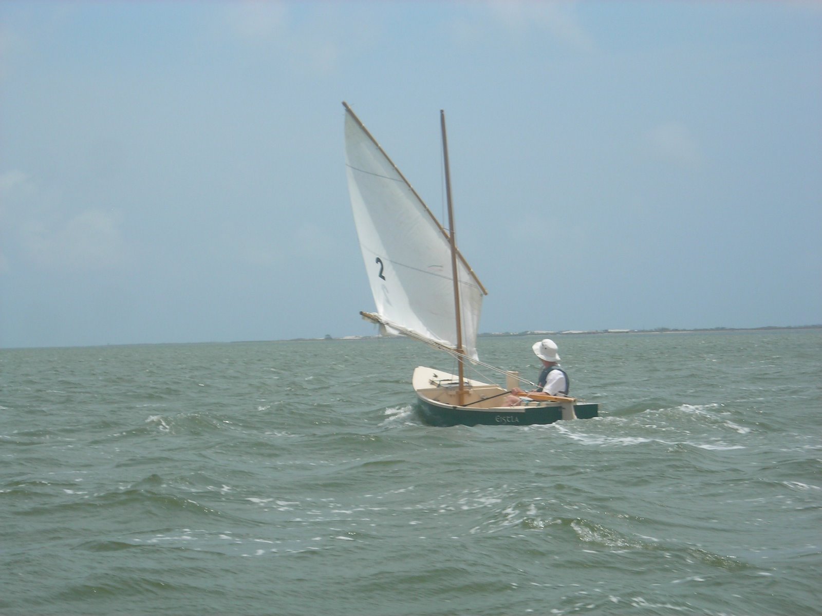
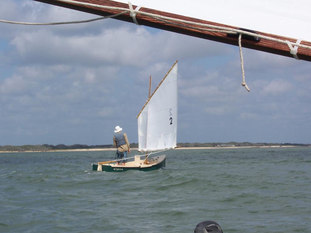
Team Eistla, 2009
The Challenge
This event started in 2008 as an expeditionary style cruise through the intercoastal areas of southern Texas. Since I had built Eistla as a camp cruiser, I thought the Texas 200 would be a perfect venue to truly test my skills in seamanship, navigation, endurance, as well as boat building and repair if necessary. Sailing alongside 40+ similar nuts for 5 days sealed the deal.
There were two major things that were foremost on my mind. The first was my condition. I’m in pretty good shape, but sitting in an open boat for extended periods of time can be taxing on tendons and muscles. The second was mechanical problems. In order for me to get to the finish, I had to make sure Eistla made it there too.
Getting to southern Texas from my home required a 2 day drive, but I got there with no problems.
Day Zero – Logistics
Because the Texas 200 did not end where it started, there were some logistics involved. Everyone brought their boat to Port Mansfield, then on Sunday morning we drove to the finish area where the organizers had cleverly found a spot to cram 40 vehicles with trailers. A chartered bus carried us back to Port Mansfield. It gave all of us a chance to get acquainted with our fellow adventurers who were from diverse backgrounds but with a shared love of boats, nature, and kooky challenges.
The bus was late getting back to Port Mansfield, so I found all restaurants within 3 miles of the Park were closed. Now it was dark, I was hungry, and I wasn’t in the mood to cook. There was nothing else for it but to turn in and hope my hunger would not keep me awake. It didn’t.
Day One – Camp at Fred Stone County Park, Port Mansfield
I was nervous. I had no idea of what to expect in terms of boat performance, length of time on the water, wind and wave conditions, campsite conditions, or number of bugs. With 5 gallons of water, did I have enough? Enough stove fuel? Enough hats in case I lose any? Advice from the skipper’s meeting the day before was still on my mind: there will be no assistance…drink lots of water…monitor your condition for heat stroke…it’s a long way to the finish if you have problems.
So I got up before dawn, finished packing, and had a quick breakfast while watching the Puddle Duck Racers depart after first light. Since they were the shortest boats in the event, there was no question that they would be spending the most time on the water. When the sun rose high enough for me to easily see two fixed channel makers on the ICW, I decided to pull my loaded boat through the shore muck and into the water. I chose to start with one reef in my balanced lug sail since the wind was already around 10 kn and expected to increase as the day wore on. Once in waist deep water it was time to take a big breath, clumsily climb into the boat, pull in the mainsheet and feel the boat surge into the Lower Laguna Madre.
The first two miles to the ICW was spent sizing up the other boats on the water. We were encouraged to find other boats that were approximately the same speed and to keep an eye on each other. Looking around I saw a few dots of sails ahead and behind, but clearly I had a jump on the majority of the participants who would probably pass me later. Within an hour I had reached over to the ICW, and now navigation for the next 2 days was clear: follow the buoys one to the next, all downwind.
As predicted the breeze increased to 15 kn around midmorning. The waves became more pronounced and my speed picked up. Eistla, despite being rather small, was stable enough in these conditions for me to stand up for periods of time. I kept up this pattern of sitting, stretching, and standing as much as I could over the next 5 days to remain limber. When the waves got big enough and Eistla began to surf, standing allowed me to shift my weight faster to take advantage of the push. Naturally there was the increased risk of falling out of the boat if it took a funny hop, but hanging on to the raised daggerboard gave me additional stability.
I started to overtake some of the boats that were ahead of me. A Bolger Cartopper, about the same size as my boat, was not able to take advantage of the waves. By the time I got to the Land Cut, a dredged channel connecting the Upper and Lower Laguna Madres, I had gotten by all of the Puddle Duckers and was slowly hauling in a Bolger Pirate Racer. Now I was getting concerned because of my first error of the trip.
I had intended to mark each of the daily destinations in indelible ink on my waterproof charts before I left home. I didn’t. I had intended to bring a list of significant GPS waypoints, which included the campsites, obstacles, and important channels. I didn’t. I knew the general area of where we going to stop for the day, plus or minus a few miles, but not the exact location. If in the unlikely event that I remained ahead of everybody and accidentally passed the camp, it would be very difficult to get back given the narrow channel and wind direction. So I sailed close to the Pirate Racer and asked if he knew where we were going. He didn’t.
I then noticed that Mr. Pirate Racer’s mast was bent at a strange angle. There were many unique and innovative boats at this event, but this seemed a little outside any designer’s intentions. I learned later that the mast was in fact a steel plumbing pipe that didn’t take kindly to the idea of holding up a large sail in breezy conditions. The bend kept increasing until the master had to improvise a new rig design using a liberal amount of duct tape.
I sailed on a bit and then beached Eistla on the side of the Cut for a lunch break. By the time I had finished, a bunch of faster boats had gone by so I felt more comfortable that they would show the way.
The breeze was now becoming quite gusty, and since I didn’t want any rig problems myself I pulled over again and put in the second reef. Afterwards I was still clipping along at a good pace but I didn’t feel like I was pressed too hard during the strong puffs.
Suddenly around 3 pm I was there—the first campsite at Hap’s Cut. I jumped out after Eistla slid to a stop and promptly sank to my knees in muck. I wore soled kayak socks that fortunately stayed on my feet. Many others were not so lucky and donated their footwear to the Texas mud.
First day’s impression: Eistla is quicker than I figured. This has a big benefit that I won’t be on the water as long, and if I have a problem I have a better chance of getting to the destination before sunset.
Day Two – Camp at Hap’s Cut
Up after first light. I try my best, but I am unsuccessful at preventing the Hap’s Cut mud from attaching to everything. When I got underway Eistla had dirt all over the cockpit. The wind was light, but I still chose to sail with one reef with the idea that it would get stronger.
After a few miles, the Land Cut ended and we entered the Upper Laguna Madre. Morning cloud cover kept the wind light, and one larger cloud actually produced a few rain drops. Once the clouds cleared, though, the breeze picked up and soon I had to put in my second reef. I was to remain with the second reef for the next 2 days.
I settled in for what was to be a parade of sailboats. I passed some, a bunch passed me. At one point I happened to notice a few dolphins ahead of me heading in the opposite direction. I tapped on the hull to attract their attention. A minute later I had 4 or 5 following me and surfacing so close aboard that I could have reached over and touched them. They got bored eventually and started playing with other boats behind me.
Slowly more civilization appeared on the horizon, and then I noticed boats turning off the channel to follow a narrow inlet. It was the entrance for the Padre Island Yacht Club. After going upwind through the narrow cut, I arrived at a busy and crowded docking area. Some well meaning folks directed me to a bulkhead where I saw other people in knee deep water tying up their boats. I got as close as I dared then jumped over the rail. Expecting shallow water, I was dismayed to find myself floating in my lifejacket and my feet touching no bottom at all. Of course my helpers were then telling me that I was too far away, but I had figured that out. I quickly scrambled back into Eistla over the side rail. Having never done that before, I was surprised to find that I had shipped no water in the process, nor had the boat turned over on top of me which is another famous dinghy trick. I think it was still a fluke, though, and would recommend to anyone having to board a Mixer to climb in over the stern. I soon was tied up in a different berth to end the day’s voyage.
Day Three – Camp at Padre Island Yacht Club
I was the most worried about this day. This was the day that we crossed Corpus Christi Bay. Everything I’ve heard about Corpus Christi Bay has the words “high winds” attached to it. Every time they have a competition where windsurfers and hydrofoils try to break the American speed records under sail, they do it in Corpus Christi Bay. And this was the first day that we had quite a few choices on how to get from the Yacht Club to the destination at Paul’s Mott, so precise navigation was required.
My main objective was to stay as close to the windward (or southern) shores as possible to avoid the chop. My next plan was to leave right at dawn to take advantage of the lighter winds. Checking the chart, there was only one spot where navigation might be confusing, and that was the entrance to the ship channel at Stingray Hole. I entered it as a waypoint into my handheld GPS. Some folks talked about crossing the ship channel and taking a back way near Stedman Island. Although it sounded attractive because it was more protected, it required going under a low bridge which meant pulling the mast out. That was certainly possible, but it added complication. I figured dodging oil tankers and ferries was easier.
Up at 5 am, a quick breakfast huddling in the lee of the Yacht Club, and I was away at 6:15; the first of our group out into the ICW. It was quiet. Eistla eased along the placid waterway. When we entered Corpus Christi Bay, I immediately turned right, setting a closehauled course to the south shore. The breeze had picked up some, but the chop was still manageable, meaning I only got splashed in the face once every 30 seconds. I need to point out that Eistla can be somewhat wet when going into the wind. I’m sure it’s a complex set of factors, but when the bow bangs down on the water, the resulting splash curls perfectly into the cockpit. And my face. I’ve always kept a small plastic cup handy to bail out the water, so I was using it 15 minutes into our new course. At least I was finally getting rid of all that Hap’s Cut mud.
Within ½ mile of shore I ran aground, so I took that as a sign I could now parallel the shore and run between Shamrock Island and Mustang Island. The wind kept building, and once I had cleared Shamrock the waves picked up enough that I was surfing regularly. I energized my GPS to help me to Stingray Hole. Running down the bigger waves the GPS speed would jump over 8 kn. I was impressed. Closer to Stingray Hole the waves started getting more confused and lumpy, but Eistla was negotiating them well.
Then I noticed a Raider ahead of me going very slowly with only a few feet of his main hoisted. That wasn’t normal so I steered within earshot and asked if he was okay. I could only make out “Yeah,” and something about losing his stuff overboard and going back to get it. I was to learn later that Mr. Raider had pitchpoled in the lumpy seas and his gear bag decided to take advantage of the distraction and escaped. Recovering it was another story that fits well in the Texas 200 annals, but mainly he felt in control of his situation so I set about negotiating the pass into the ship channel.
Once in the ship channel, I was relieved. It meant I crossed Corpus Christi Bay and had some flat water for the next 10 miles or so. Sure, there was the obligatory oil tanker, barge, and set of ferries to negotiate. But getting past them was straight forward, as was the turn into Lydia Ann Channel. When I got to Murray Shoal I faded off to the right. My chart showed a small channel between Mud Island and San Jose Island, and I had planned to take it to cut some distance and remain in more protected water. I was somewhat relieved that the John’s Sharpie/Trimaran, which had passed me earlier, was taking the same route. Mr. and Mrs. John’s S/T were locals and would know if routes would be passable. An hour later I saw them backtracking along the south shore of Mud Island. That had me really concerned. Did they find the channel silted in? I crossed my fingers and continued. As usual, I found the landscape around the channel different from the chart, but a few powerboats puttering about showed that there was enough water for me to sneak through. Next stop, Paul’s Mott.
Which was another mystery. My chart showed a general fishing region called Paul’s Mott. I was hoping that enough boats would already be there to show where the campsite was. When I got to that region, I skirted as close as I dared to shore, running aground several times, but saw no one. Then I noticed other boats running aground trying to cross a small shoal farther on, so I followed them. Behind a spit of land several boats were beached, so I skirted wide of the shoal and walked the boat into the oyster beach. It was the end of a very rewarding day. Once I had set up the tent and started to relax, I realized that the wind was really kicking. My thought was, “I was sailing in that?”
Day Four – Paul’s Mott
Like the previous day, we had several choices of where to go. Quite a bit of talk at the campsite was about Ayres Dugout. That route required multiple GPS waypoints and lots of potential of getting lost and confused, so I chose the ICW until San Antonio Bay. Then I would follow my usual plan of skirting the southern shore of the bay. Since I had survived Corpus Christi Bay pretty well, I figured the worst was behind me.
I was wrong.
Up at 5 am again, off before sunrise to again take advantage of the lighter breeze. By the time sun was peeking through the puffy clouds the wind was already picking up. I then committed the second error of the trip.
I could see the ICW. I could see an unbreakable line of brushy shoreline to the northeast. This land did not seem to match the chart. And then there’s Deadman’s Island. It appears large as life on the chart, but I was to find out later it doesn’t exist anymore. This lack of clear and verifiable landmarks had me slightly confused. This confusion became much greater when my daggerboard started grinding on oyster beds. Not knowing exactly where to go, I headed straight for the ICW. I grounded again, but eventually I was clear of the shoals and in the ICW. Passing the first marker added to the confusion. I was much farther east than I was thinking. The next few buoy numbers were completely out of whack. The buoys were the right color (red to port, green to starboard), but the numbers weren’t matching anything on the chart. I finally pulled out my GPS and got the clearest indication of where I was—in the ICW, next to Dunham Island. I soldiered on.
Despite the fluky wind caused by the nearby islands, I slowly started to pass a tug pushing a barge. This took me several miles since I had to get close to the bank to stay out of his way, which had less breeze, which slowed me down, then he’d pull ahead. Eventually I got past him, and continued on my merry way until I got to buoy “51”, which was labeled correctly. I turned right, and that’s when things got really interesting.
I was now in the full force of the wind. Although not abnormally high (around 15 to 20 kn), it had kicked up a pretty good chop. On my lee side was an area listed on the chart as ‘Spoil Area’ in a blue color. This gives the impression that it’s still underwater, but this area was now a full-fledged spoil island surrounded by some kind of rubber retaining wall. Waves hitting this wall simply bounced back, creating an almighty washing machine. And now I was sailing close-hauled through this mess. Eistla hobbyhorsed over the waves, banging relentlessly on every wave, sending spray into the cockpit and over me. Sometimes I got stopped dead and had to bear off a bit to gain speed again. I peered under the boom to find that I was edging closer to the rubber wall. I started to bail a little bit, but I stopped because I needed all my concentration on keeping the boat going. Several unusual waves slopped water over the leeward rail, adding to the significant quantity already sloshing around. I kept nervously checking my progress on the spoil area. Slowly, ever so slowly, I crept past it. Once I was comfortably clear, I started bailing in earnest. A full 10 minutes later I had gotten it down to a manageable level. The spray continued on every wave, so I had to bail every 2 minutes. This was my pattern for the next hour as I crossed over to Matagorda Island.
When I closed with the southern shore I got relief from the larger waves, but not from the splashing. As I headed on a beam reach for Panther Point, the chop was still enough to force me to bail regularly. I decided to get farther away from shore, hoping the larger waves would be far enough apart to lessen the spray. It actually worked, and by the time I grounded my way across Panther Reef I didn’t have to bail very much.
I now headed for a GPS waypoint at South Pass. The larger waves allowed me to surf—my GPS spiking up to 8.5 knots on one delightful sprint. My course converged with a Sea Pearl who was heading for the same pass. The Princess 22 was ahead of us and cleared the unmarked channel with no problems so we followed suit. From South Pass it was a beam reach to Army Hole, our next camping site.
For some reason the water conditions were less traumatic in Espiritu Santo Bay even though the wind speed was the same. It was welcome, though. I was actually able to eat a little snack while sailing, which I hadn’t been able to do in the past 2 days. Once I got to Army Hole I was early enough that I had my pick of a landing spot. Boats trickled in the rest of the day, many with horror stories about Ayres Dugout.
Day Five – Army Hole
On this day there were two choices. The hard way, and the easy way. Since my main goal was to get to the finish and we weren’t there yet, the easy way sounded best. Again I was first out on the water, followed shortly by a few others. The wind did not have the same punch as the day before, but I still chose to start with my 2 reefs. The dead downwind course allowed me to stand a bit more to stretch out, but surprisingly I had not suffered from sitting as much as I had thought. By the time I got to the ICW the breeze had slackened enough that I risked taking out a reef.
The ICW was pretty busy; lots of fishing boats, seiners, people just enjoying the sunny conditions. It was more entertaining viewing than the scrubby dunes that make up most of the ICW shoreline. Eventually I cleared the jetty into Matagorda Bay and gybed. I was now uncharacteristically on a port tack.
The wind remained docile, and other boats started to pass me. I considered shaking out my reef and showing my full sail for the first time but decided against it. Any failure at that point would mean a long row to the finish, and sailing is a lot less taxing. So there was nothing to do but steer, watch the landscape go by, monitor the boats ahead to see where they go, and periodically slather on sun-screen. Such is the story of endurance events if you’re lucky.
Eventually I passed Indian Point. I saw the boats ahead of me go about 1/2 a mile and turn into the beach. This was it! I picked a spot among the finishers and nosed Eistla into the soft sand. It was over.
Conclusion
I am extremely grateful that Eistla was able to carry me and my camping gear 180 or so miles along the Texas lagoons without any problems. My careful preparations at making Eistla an expedition dinghy worked well. Very little water got into the storage tanks which kept things tolerably salt-free when I got to the campsites. The balanced lug rig is simple, easy to reef, and keeps control of the sail in all conditions. Despite being overloaded with too much water, too much food, and too much stove fuel, Eistla behaved well, surprising me and others with fast passages for a 12 foot boat. It tolerated many groundings, scraping across oyster shell beaches, and bouncing for 2600 miles on a trailer. It looks a little worse for wear, but it’s still an achievement of which I can be proud.
Would I do it again? Not in a Mixer. Something bigger and drier.